Subscribe for all my updates and don't miss a thing! Sign me up!
Why Is Jamaica Divided Into Parishes?
 Answered by Tracie Shortridge, Associate Writer
The current design of our beautiful island of Jamaica is a uniquely shaped and artistically bordered vision.
Take a walk with me on this journey of how the boundaries resulted in the creation of the parishes in Jamaica.
Ranches
Prior to the parishes, there were literally two named ranches owned by the Spaniards called Yallahs and Morant. They were the largest ranches on the island and were therefore used as border markers.
At this time, other than the Yallahs and Morant ranches, the capital of Jamaica was Seville.
With other ranches being developed over the years, there came a need for more markers to differentiate the regions and ranches of the now Spaniard-led Jamaican population.
So, the division took place.
This was between 1572 and 1655. The ranches identified on the map from this division were:-
- Northside
- Bluefields
- Withywood
- Guanaboa
- Spanish Town
- Liguanea
- Yallahs
- Morant
The First Parishes
Then the English took over in 1655 and decided that all these ranches were not only too large to be bearing one name and one boundary but also that the country needed a better administrative structure so this gave birth to the first parishes.
This started with seven parishes:-
- Clarendon
- St. John’s
- St. Andrew’s
- St. Katherine’s
- Port Royal
- St. David’s
- St. Thomas
As you may have noticed with the names, all these parishes were named after wealthy and distinguished people in the English regime.
But with the growth of the trade industry, more parishes were added.
Parishes were created quickly and even had two unnamed parishes until later years.
By 1675, Jamaica boasted a total of 14 parishes. They are as follows in order from West to East:-
- Unnamed
- St. James
- St. Ann
- St. Mary
- St. George
- St. Thomas
- St. Elizabeth
- Unnamed
- Clarendon
- St. John
- St. Catherine
- St. Andrew
- Port Royal
- St. David
By 1692, other boundaries were created resulting in two additional parishes, with a total at this point of sixteen. They were:-
Kingston was then added in 1703 making it a total of seventeen parishes.
In 1722, the new Governor of Jamaica, the Duke of Portland, created the parish of Portland from St. George and St. Thomas.
He also separated one unnamed parish into two parishes and called them Hanover and Westmoreland.
The Counties
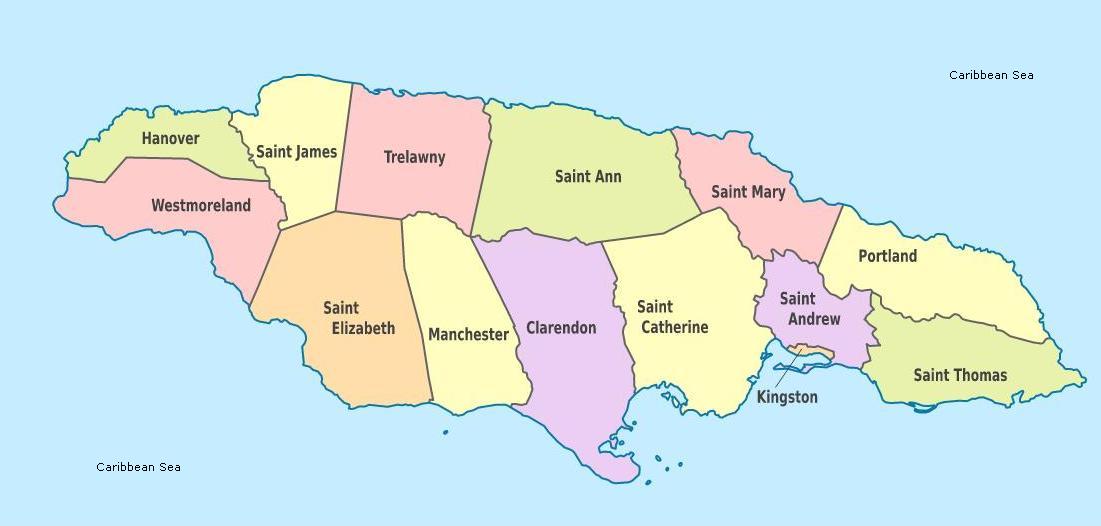
To further ensure clear and vivid parish lines, the parishes were grouped into three counties, Cornwall, Middlesex and Surrey.
In 1814, one new parish was added making it a total of 21 parishes.
The parishes stayed in this order until 1842 when, upon exiting office, Governor Sir Charles Metcalfe was honoured with a parish being named after him, namely, Metcalfe, which was through the elimination of St. George and St. Mary.
The Elimination & Merger Of Some Parishes
Then, in 1867, eight parishes were eliminated and other parishes were merged resulting in what we have today, a total of fourteen parishes!
Cornwall County
PARISH          CAPITAL
Hanover	        Lucea
Saint Elizabeth	Black River
Saint James	Montego Bay
Trelawny	Falmouth
Westmoreland	Savanna-la-Mar
Middlesex County
PARISH          CAPITAL
Clarendon	May Pen
Manchester	Mandeville
Saint Ann	Saint Ann's Bay
Saint Catherine	Spanish Town
Saint Mary	Port Maria
Surrey County
PARISH          CAPITAL
Kingston Parish	Kingston
Portland	Port Antonio
Saint Andrew	Half Way Tree
Saint Thomas	Morant Bay
So, why is Jamaica divided into parishes?
Simple… as regular people device their own unique visions and plans for the future, so too did the leaders of the various administrations. And, based on their vision of growth and economics, they devised what they conceived as the best way forward for the country.
Be sure to read more about each of the parishes here. Read more about the history of Jamaica here as well.
Sources Referenced:
- https://en.wikipedia.org/wiki/Surrey_County,_Jamaica
- Caribbean History for CSEC, by Radica Mahase, Kevin Baldeosingh, 2011
New! Get My Latest Book👇🏿
|
You asked, I've answered! You no longer need to save for months or years, to enjoy paradise! I spilled the beans! sharing my top tips on finding cozy accommodations and secret gems, only the way a native could! Click Here to pick it up on my e-store and start saving now! |
See The Best Of Jamaica - In Videos!
|
My channel reaches over 140,000 subscribers worldwide and has leveraged over 11 million views, sharing, what I call 'The Real Jamaica'. Subscribe today and join our family of viewers. |
Read More ...
New! Experience The REAL Jamaica!
Book Your Private Tour here and experience Jamaica the way we (locals) do!
P.S. Didn't find what you were looking for?
Still need help?
Click Here to try our dependable and effective Site Search tool. It works!
Or, simply click here and here, to browse my library of over 500 questions and answers! Chances are someone already asked (and got an answer to) your question.


